 GIS ObjectLand 2.7.7
GIS ObjectLand is a universal Geographic Information System for Windows. Key features: using spatial data and tables from internal or external DBMS; multiuser data editing; import/export for MIF/MID, SHP, DXF, DBF, CSV; access permissions for users.
Last update
31 Jul. 2012
| old versions
Licence
Free to try |
$199.00
OS Support
Windows Me
Downloads
Total: 1,751 | Last week: 1
Ranking
#774 in
Databases Tools
Publisher
Radom-t
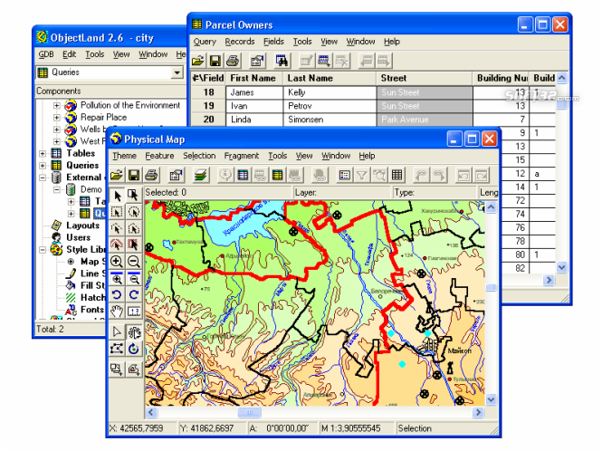
Screenshots of GIS ObjectLand

GIS ObjectLand Publisher's Description
GIS ObjectLand is a universal Geographic Information System for Windows.
Key features:
- creation of vector-raster maps with arbitrary structure of layers and feature types in an internal ObjectLand database or in following DBMSs - MS SQL Server, Oracle, DB2, MySQL, Interbase/Firebird, PostgreSQL, MS Access;
- creation of themes. Theme is a user presentation of a map;
- control of displaying features depending on the chosen scale;
- spatial data input and editing by assigning feature coordinates and also by interactive drawing with mouse or digitizer;
- sewing of separate pages of an imported map into one unified continuous map;
- copying, merging, and moving maps, layers, and feature types between different geoinformation databases;
- creation of tables of arbitrary structure;
- creation of queries. Query is a user presentation of table built by setting search and sorting conditions, joining tables, calculations and using reference tables;
- copying, merging, and moving tables and queries between different geoinformation databases;
- setting arbitrary links between spatial and table information;
- getting information about the feature selected on the map;
- searching for features on the map by linked records;
- creation of filters. Filter is conditions of feature visualization depending on spatial properties of features and linked table data;
- creation of layouts. Layout is an output form combining spatial, table information and presentation elements;
- import and export of table and spatial information for widespread data formats;
- support of style libraries containing fonts, map symbols, line styles, hatches and fill styles;
- style editors for displaying styles;
- setting for users the access permissions to components;
- multiuser data editing;
- using and editing tables of external database (via ODBC) as linked tables;
- providing automation COM interfaces for user applications.
Look for Similar Items by Category
Feedback
- If you need help or have a question, contact us
- Would you like to update this product info?
- Is there any feedback you would like to provide? Click here
Beta and Old versions
Popular Downloads
-
 Kundli
4.5
Kundli
4.5
-
 Grand Auto Adventure
1.0
Grand Auto Adventure
1.0
-
 Macromedia Flash 8
8.0
Macromedia Flash 8
8.0
-
 Cool Edit Pro
2.1.3097.0
Cool Edit Pro
2.1.3097.0
-
 Grand Theft Auto: Vice City
1.0
Grand Theft Auto: Vice City
1.0
-
 Hill Climb Racing
1.0
Hill Climb Racing
1.0
-
 Cheat Engine
6.8.1
Cheat Engine
6.8.1
-
 Zuma Deluxe
1.0
Zuma Deluxe
1.0
-
 Tom VPN
2.2.8
Tom VPN
2.2.8
-
 Vector on PC
1.0
Vector on PC
1.0
-
 Grand Theft Auto IV Patch...
1.0.1.0
Grand Theft Auto IV Patch...
1.0.1.0
-
 Netcut
2.1.4
Netcut
2.1.4
-
 Minecraft
1.10.2
Minecraft
1.10.2
-
 Ulead Video Studio Plus
11
Ulead Video Studio Plus
11
-
 AtomTime Pro
3.1d
AtomTime Pro
3.1d
-
 Windows XP Service Pack 3
Build...
Windows XP Service Pack 3
Build...
- Bluetooth Device (RFCOMM Protocol... 5.1.2600.2180
-
 C-Free
5.0
C-Free
5.0
-
 Hercules Setup Utility
3.2.8
Hercules Setup Utility
3.2.8
-
 Microsoft Office 2010
Service...
Microsoft Office 2010
Service...